Posts Tagged 'prehistoric'
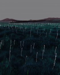
king aurthur’s moor. from place to place. light drawing.
king arthur’s moor. from place to place. light drawing. a non-intrusive intervention originally carried out on dungeness beach. a project proposition for king arthur’s hall. as with all works of installation or landart the intervention brings with it a sense
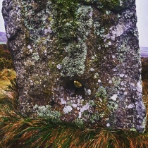
a hole in four (or maybe five) holed stone row. botallack common. west penwith
a hole in four (or maybe five) holed stone row botallack common.
a line of holed stones on moorland at botallack common lie at approximately 168m above od. four holed stones were noted and sketched in 1842 by the reverend buller. a further fifth stone was recognised by blight in 1908 although this remains in question. four large roughly cut regular granite slabs, partly recumbent, are set in an alignment orientated wsw-ene. they have bevelled perforations, with an average 7.5cm to 9cm in diameter. only half of one stone still survives with the fracture across the perforation. the fifth outlying stone which unlike the others is not in alignment, not bevelled but with a straight sided hole. the function of the monument is unknown; possibly part of a short stone row and should perhaps be considered as part of other ceremonial activities, close to the tregaseal circle and barrows (the term ‘ordnance datum’ OD, refers to the height of mean sea-level, taken from a reference point at newlyn in cornwall. this is basis of the national height system for the whole of britain
more at montagecity.com
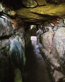
recent discoveries at bryn celli ddu.
recent discoveries at bryn celli ddu.
a geophysical survey was conducted, recently, around the bryn celli ddu chambered tomb exposing evidence of a cairn cemetery. the 5,000-year-old tomb, a complex dating from the neolithic through to early bronze age, was also found to include the at least four burial cairns and a cluster of prehistoric pits with pottery deposits, worked flint, and tools. its relationship to the summer equinox was tested confirming that the main passage focuses the light along its length and illuminating the entire polygonal stone chamber.
in addition 8 new cupmarked rock art on associated outcrops have been identified, using 3d scanning techniques. a dumbbell motif surrounded by singular cup-marks, cup-marks in close formation, possibly in the form of a rosette and one with a large cup-mark
recent discoveries at bryn celli ddu.
recent discoveries at bryn celli ddu.
a geophysical survey was conducted, recently, around the bryn celli ddu chambered tomb exposing evidence of a cairn cemetery. the 5,000-year-old tomb, a complex dating from the neolithic through to early bronze age, was also found to include the at least four burial cairns and a cluster of prehistoric pits with pottery deposits, worked flint, and tools. its relationship to the summer equinox was tested confirming that the main passage focuses the light along its length and illuminating the entire polygonal stone chamber.
in addition 8 new cupmarked rock art on associated outcrops have been identified, using 3d scanning techniques. a dumbbell motif surrounded by singular cup-marks, cup-marks in close formation, possibly in the form of a rosette and one with a large cup-mark

trevalgan hill cave.
trevalgan hill. cave. this is a place which holds the imagination _ where the cover stone is held upright to announce its entrance such that one questions its status as a natural formation. could it not be be formed and
trevalgan hill cave.
trevalgan hill. cave. this is a place which holds the imagination _ where the cover stone is held upright to announce its entrance such that one questions its status as a natural formation. could it not be be formed and

neolithic long carn or barrow. chaple carn brea west penwith.
neolithic long carn or barrow. chaple carn brea west penwith. the last high point before the western sea board and the site of much prehistory – heavily populated by a range of neolithic and bronze age long and round barrows entrance graves and carns. it is an important ceremonial site in view of the atlantic with many of its sites unexcavated. comprises an elongated stony mound, oriented NNW to SSE, situated on a crest above a slight southern slope. It is 26m long and varies between 5.0m and 6.0m wide. within this width comprises a flattened mound of small tightly packed stones, which at the northern end broadens to 3.2m. seven earthfast stones occur at irregular intervals by the edge of the flat mound and again towards the perimeter of the mound. these average between 0.1m to 0.3m but one of two leaning stones is 0.9m high. there are at least seventeen displaced blocks or slabs averaging 1.0m long and 0.7m wide on the mound and around its perimeter, but with no obvious sockets to confirm that they are part of a displaced kerb. one of the most interesting features is the way it incorporates a large 15m horizontal outcrop. initially level with the stone mound, this now rises 1.7m above it and at the southern end is 3.0m above the present ground level. along its axis small stones have been packed against and into its crevices. probably important before the carn was built, these outcrops have had their meaning and myths transferred to the barrow to enhance its status and presence in this ceremonial landscape
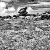
prehistoric propped stone. zennor hill. west penwith
prehistoric propped stone. zennor hill. weat penwith. this gives a greater idea of the context for this with the plateau that lies in front on the megalithic stone feature. it can be read across the land-scape as soon as one
prehistoric propped stone. zennor hill. west penwith
prehistoric propped stone. zennor hill. weat penwith. this gives a greater idea of the context for this with the plateau that lies in front on the megalithic stone feature. it can be read across the land-scape as soon as one