Posts Tagged 'westpenwith'
walking the rosewall hill, ancient stones in an ancient landscape westpenwith
rosewall hill famed for long and ancient history of tin mining is also an in many ways an recorded site of prehistory and ancient landscape with a few known monuments an odd standing stone and the remnants of a curbed
walking the rosewall hill, ancient stones in an ancient landscape westpenwith
rosewall hill famed for long and ancient history of tin mining is also an in many ways an recorded site of prehistory and ancient landscape with a few known monuments an odd standing stone and the remnants of a curbed
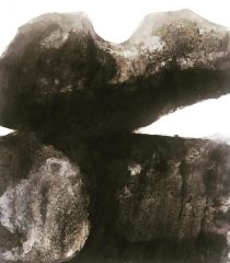
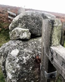
carnstabba loganstone. halsetown. this two-tier bolder contains solutions basins on both.
carnstabba logan stone. halsetown. this two tier bolder contains solutions basins on both and its silhouette can be seen on the carnstabba horizon from miles around. it’s family resemblance to its cousins the west penwith quoits is remarkable. undoubtably one
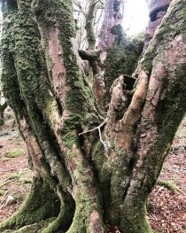
trees over rocks. sunday walk steeple woods. mine workings.
the rock bed is very close to the surface on the old mine working areas on the down slopes of steeple woods. this creates tree structures with roots that have little room to develop and that are vulnerable to uprooting
trees over rocks. sunday walk steeple woods. mine workings.
the rock bed is very close to the surface on the old mine working areas on the down slopes of steeple woods. this creates tree structures with roots that have little room to develop and that are vulnerable to uprooting
S.H.E.D. reuse – reclaim – reinstate.
S.H.E.D. reuse – reclaim – reinstate.
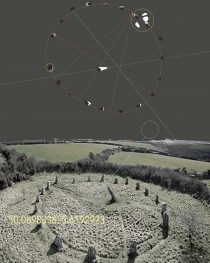
boscawen-un stone circle 50.223456,-5.123456. constructed image.
one of the five stone circles left standing in west penwith cornwall. although many more existed but have been lost over the last two centuries. the merry maidens circle is intervisible with it and can be seen just below the
boscawen-un stone circle 50.223456,-5.123456. constructed image.
one of the five stone circles left standing in west penwith cornwall. although many more existed but have been lost over the last two centuries. the merry maidens circle is intervisible with it and can be seen just below the
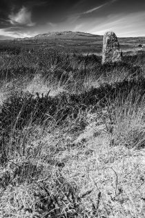
standing stone trink hill.
View on Instagram https://instagr.am/p/B_zsP0yHXbr/ a single stone on a hillside of unusual stones, stone carns, barrows and a natural stone feature known locally as the grandmothers stone or twelve o’clock rock. trencrom enclosure can be seen on the horizon
standing stone trink hill.
View on Instagram https://instagr.am/p/B_zsP0yHXbr/ a single stone on a hillside of unusual stones, stone carns, barrows and a natural stone feature known locally as the grandmothers stone or twelve o’clock rock. trencrom enclosure can be seen on the horizon
carnstabba giant’s stone moon rising. halsetown / gibraltar walk road works. bethnal green.
carnstabba giant’s stone moon rising. halsetown / gibraltar walk road works. bethnal green.
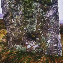
the giant’s stone is a huge 8x3x3 m monster granite bolder oriented towards the west and displaying its cup marks and water basin. seen here in conjunction with a rising full moon. of possible archaeological significance
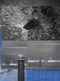
gibraltar walk road works. a cobbled street with granite sets off bethnal green road and close to brick lane. steel fencing sealing off a protected dig. gas not archaeology-text
more at montagecity.com
carnstabba giant’s stone moon rising. halsetown / gibraltar walk road works. bethnal green.
carnstabba giant’s stone moon rising. halsetown / gibraltar walk road works. bethnal green.
the giant’s stone is a huge 8x3x3 m monster granite bolder oriented towards the west and displaying its cup marks and water basin. seen here in conjunction with a rising full moon. of possible archaeological significance
gibraltar walk road works. a cobbled street with granite sets off bethnal green road and close to brick lane. steel fencing sealing off a protected dig. gas not archaeology-text
more at montagecity.com
a hole in four (or maybe five) holed stone row. botallack common. west penwith
a hole in four (or maybe five) holed stone row botallack common.
a line of holed stones on moorland at botallack common lie at approximately 168m above od. four holed stones were noted and sketched in 1842 by the reverend buller. a further fifth stone was recognised by blight in 1908 although this remains in question. four large roughly cut regular granite slabs, partly recumbent, are set in an alignment orientated wsw-ene. they have bevelled perforations, with an average 7.5cm to 9cm in diameter. only half of one stone still survives with the fracture across the perforation. the fifth outlying stone which unlike the others is not in alignment, not bevelled but with a straight sided hole. the function of the monument is unknown; possibly part of a short stone row and should perhaps be considered as part of other ceremonial activities, close to the tregaseal circle and barrows (the term ‘ordnance datum’ OD, refers to the height of mean sea-level, taken from a reference point at newlyn in cornwall. this is basis of the national height system for the whole of britain
more at montagecity.com