megalithic-atlas
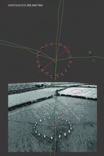
merry maidens stone circle(s)
merry maidens stone circle(s) the merry maidens (sw 4327 2450) is one of the few ‘true’ stone circles in cornwall, being based on a perfect circle; it comprises nineteen stones today but is thought to originally have consisted of just

merry maidens stone circle(s)
merry maidens stone circle(s) the merry maidens (sw 4327 2450) is one of the few ‘true’ stone circles in cornwall, being based on a perfect circle; it comprises nineteen stones today but is thought to originally have consisted of just

ur-history – remembrance – surrealist procedures
ur-history – a form of collective remembrance. the basic distinction to be made between the monuments of prehistory and say the monuments of the nineteenth century in any metropolitan city is that unlike the monuments of the recent past the

ur-history – remembrance – surrealist procedures
ur-history – a form of collective remembrance. the basic distinction to be made between the monuments of prehistory and say the monuments of the nineteenth century in any metropolitan city is that unlike the monuments of the recent past the
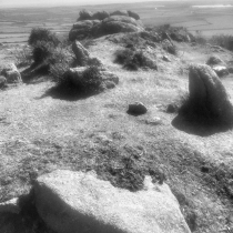
chapel carn brea _neolithic long barrow.
_chapel carn brea _neolithic long barrow or cairn. this unique monument sits on the crest of this last hill on west penwith peninsula or the first on uk’s land mass if you were travelling up from the iberian coastal waters.

chapel carn brea _neolithic long barrow.
_chapel carn brea _neolithic long barrow or cairn. this unique monument sits on the crest of this last hill on west penwith peninsula or the first on uk’s land mass if you were travelling up from the iberian coastal waters.

modern archaeology, ancient architecture.
archaeologists have literally walked through history after discovering britain’s oldest pavement. the unique stone pathway was built more than 4,000 years ago and is the only one of its kind in the uk. experts at the site claim the 4ft

modern archaeology, ancient architecture.
archaeologists have literally walked through history after discovering britain’s oldest pavement. the unique stone pathway was built more than 4,000 years ago and is the only one of its kind in the uk. experts at the site claim the 4ft
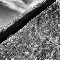
zennor quoit. neolithic chambered tomb.
zennor quoit. neolithic chambered tomb. w borlase the antiquarian drew a plan of the site in the mid-c18 when the capstone was roughly horizontal and the chamber was set into a low stony mound approx 12.8m in diameter. by the time his great-great grandson visited the site in the middle of the c19, the capstone had slipped and the western upright supporting it had snapped.
the site today comprises two chambers set into a low stony mound. the main chamber is trapezoidal with its long axis running off NNE by 75 degrees. the western end is 0.83m wide, reducing to 1.9m. the total length being 3.16m. the capstone now tilted and following the line of the supporting stones is 5.33m by 2.9m and weighs about 9.45 tonnes. it has an antechamber at the eastern end formed by two impressive portal stones.
quoits are among the oldest megalithic architecture on the west penwith peninsula and would have represented a local variation of a tradition which had travelled from the levant up the west coast of spain to brittany, to arrive in cornwall in the late neolithic, around 3300 bce on route to wales, anglesea and ireland

neolithic long carn or barrow. chaple carn brea west penwith.
neolithic long carn or barrow. chaple carn brea west penwith. the last high point before the western sea board and the site of much prehistory – heavily populated by a range of neolithic and bronze age long and round barrows entrance graves and carns. it is an important ceremonial site in view of the atlantic with many of its sites unexcavated. comprises an elongated stony mound, oriented NNW to SSE, situated on a crest above a slight southern slope. It is 26m long and varies between 5.0m and 6.0m wide. within this width comprises a flattened mound of small tightly packed stones, which at the northern end broadens to 3.2m. seven earthfast stones occur at irregular intervals by the edge of the flat mound and again towards the perimeter of the mound. these average between 0.1m to 0.3m but one of two leaning stones is 0.9m high. there are at least seventeen displaced blocks or slabs averaging 1.0m long and 0.7m wide on the mound and around its perimeter, but with no obvious sockets to confirm that they are part of a displaced kerb. one of the most interesting features is the way it incorporates a large 15m horizontal outcrop. initially level with the stone mound, this now rises 1.7m above it and at the southern end is 3.0m above the present ground level. along its axis small stones have been packed against and into its crevices. probably important before the carn was built, these outcrops have had their meaning and myths transferred to the barrow to enhance its status and presence in this ceremonial landscape
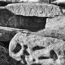
tregiffian entrance tomb.
tregiffian entrance tomb. considered part of the scillonian group of ‘entrance graves’ and is one if the earliest of its type in cornwall. It is within 90m of the merry maidens stone circle. It has been suggested along with bants carn as not being primarily sepulchral but rather repositories or chambers connected with land fertility rituals. (ashbee). topographically its position out on the l00m coastal platform of penwith contrasts with that of most other Entrance tombs which lie close to the 125m contour at the junction between the coastal platform and the high moorlands of west oenwith. significantly, the original 17m diameter circular turf mound retained by a megalithic kerb finds close comparison in irish late neolithic passage tombs. while the packing stones inside the kerb are reminiscent of ruined passage tombs at carrowmore. rhe decoration of the jamb stone on the east side of the entrance to the tomb with oval and circular cup marks is paralleled in megalithic tombs in western and northern europe, so one might understand this as a local interpretation of evolving tradition across europe . the barrow and kerb at tregiffian were reconfigured to roughly polygonal form, probably during the early bronze age when two cremation burials in collared food urns were placed in pits within the chamber. the oval cup marks on the entrance blocking stone are unique in cornwall
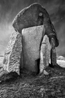
trethevy quoit
trethevy quoit is sited on a promontory overlooking the confluence of streams which flow southwards to become the river seaton; the northern skyline is dominated by caradon hill and granite massif of minions moor four large overlapping granite slabs set

trethevy quoit
trethevy quoit is sited on a promontory overlooking the confluence of streams which flow southwards to become the river seaton; the northern skyline is dominated by caradon hill and granite massif of minions moor four large overlapping granite slabs set
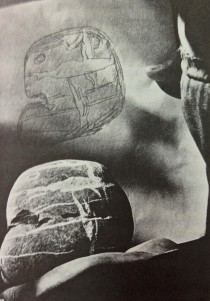
the materiality of stones
the early modernist concern to ‘let the material speak’ can be traced back to prehistory. the materiality of the stones selected for use in prehistory’s ceremonial assemblages is one of great importance, where certain stones are carefully chosen for there surface texture, visual tactility,
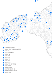
west penwith: axe production and distribution as a guide to prehistoric connectivity
the distribution of lithic material and its suggested disposition of axe factories at this point creates a fascinatingly complex and gradually unfolding picture of prehistoric interaction. a series of stages of activity is suggested — stage 1 is difficult to
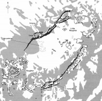
tor enclosures
at roughtor a well preserved stone-built tor enclosure incorporates the natural outcrops of roughtor and little roughtor. its stony banks are shown as solid black lines in this plan to the right. it was surveyed on the ground by english

tor enclosures
at roughtor a well preserved stone-built tor enclosure incorporates the natural outcrops of roughtor and little roughtor. its stony banks are shown as solid black lines in this plan to the right. it was surveyed on the ground by english
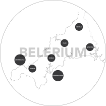
montage-modernity-and the wild west
montage with its spatial origins in dublin (joyce), paris (surrealism), berlin (dada, brecht, hartmann)) and moscow (eisenstein vertov), the increasingly fragmented world gives rise to the the technique of fragment. benjamin sees the passagenwork as a lexicon of capitalist modernity, its
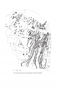
pattersdale rock engravings
the complex includes five closely-spaced examples of prehistoric rock art in patterdale. they are all located on a low, tree-covered rock and gravel outcrop of close-grained igneous rock on low-lying ground a short distance east of goldrill beck 270m north west

pattersdale rock engravings
the complex includes five closely-spaced examples of prehistoric rock art in patterdale. they are all located on a low, tree-covered rock and gravel outcrop of close-grained igneous rock on low-lying ground a short distance east of goldrill beck 270m north west
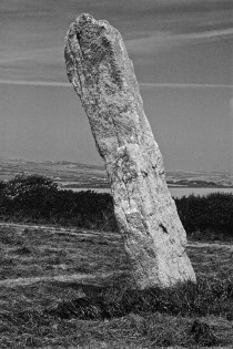
stone replaces wood
walking — walking on two feet is the only means of mobility. — virgin land difficult to traverse heavily forrested rivers and sea major means of communication forests natural barriers — tracks established by migrating animals open up the higher

stone replaces wood
walking — walking on two feet is the only means of mobility. — virgin land difficult to traverse heavily forrested rivers and sea major means of communication forests natural barriers — tracks established by migrating animals open up the higher
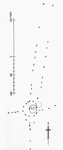
callanish stones. the moon, sun, land and sea.
it is thought the erection of the first stones at callanish I (tursachan calanais) began around 3000bc. the construction started with the tallest, central monolith, [burl suggests as a navigational aid] and then is encompassed by a flattened circle of

callanish stones. the moon, sun, land and sea.
it is thought the erection of the first stones at callanish I (tursachan calanais) began around 3000bc. the construction started with the tallest, central monolith, [burl suggests as a navigational aid] and then is encompassed by a flattened circle of
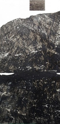
water and stone, sea and shell, tree and soil, bone and ash.
50.22106 -5.24829 detail/ rosewall hill rocking stone 120x170cm/ oil glass bitumen ash shell bone silicon. water and stone, sea and shell, tree and soil, bone and ash, sun and moon. all have a place in the ancient cosmos. the neolithic peoples knew the
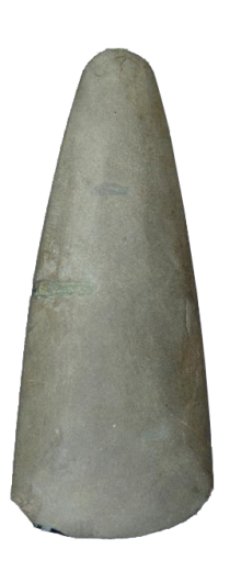
langdale axe
neolithic polished stone axe head. epidotised ash from langdale. found at lydham, shropshire.

langdale axe
neolithic polished stone axe head. epidotised ash from langdale. found at lydham, shropshire.
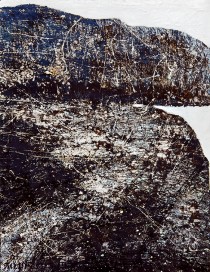
carnstabba logan stone
paint-work. oil and mixed media onto board.120cmx180cm logan stones are called such for their ability to move in relation to the tor or grounder of which it is associated. this might, as is the case of the stone at treen

carnstabba logan stone
paint-work. oil and mixed media onto board.120cmx180cm logan stones are called such for their ability to move in relation to the tor or grounder of which it is associated. this might, as is the case of the stone at treen
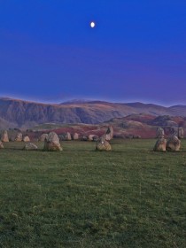
castlerigg stone circle
situated on chestnut hill it is supremely sited amonst the surrounding mountains and is probably one of the earliest neolithic stone circles constructed in britain around 3200BC. it corresponds to the most active period in cumbria for the production of

castlerigg stone circle
situated on chestnut hill it is supremely sited amonst the surrounding mountains and is probably one of the earliest neolithic stone circles constructed in britain around 3200BC. it corresponds to the most active period in cumbria for the production of
gobekli tepe
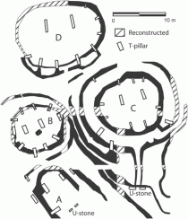
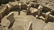
göbekli tepe (turkish for ‘hill with a tummy’), which is a hilltop sanctuary built on the highest point of an elongated mountain ridge about 15km northeast of the town of şanlıurfa (urfa)in southeast turkey. it is said to have been

gobekli tepe
göbekli tepe (turkish for ‘hill with a tummy’), which is a hilltop sanctuary built on the highest point of an elongated mountain ridge about 15km northeast of the town of şanlıurfa (urfa)in southeast turkey. it is said to have been
megalithic trails
gobekli tepe. large ceremonial complexes dating from the 9th millennium BC have been discovered at a number of sites in eastern turkey. they belong to the incipient phases of agriculture and animal husbandry. large circular structures involving carved megalithic orthostats are

megalithic trails
gobekli tepe. large ceremonial complexes dating from the 9th millennium BC have been discovered at a number of sites in eastern turkey. they belong to the incipient phases of agriculture and animal husbandry. large circular structures involving carved megalithic orthostats are
quoits–cornish portal dolmen
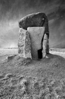
Trevethy Quoit – Portal Dolmen. trethevy quoit was originally covered by a mound. known locally as ‘the giant’s house’. the remnants of this suggest a diameter of 6.5 metres. the remaining six stones (originally 7) and the 3.7 m long and

quoits–cornish portal dolmen
Trevethy Quoit – Portal Dolmen. trethevy quoit was originally covered by a mound. known locally as ‘the giant’s house’. the remnants of this suggest a diameter of 6.5 metres. the remaining six stones (originally 7) and the 3.7 m long and
dolmen. passage graves. gallery graves, quoits
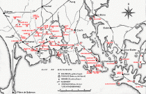
the dolmen are megalithic tombs built of stone. most were probably covered by a mound of earth and/or stone. the older ones were family or community graves, used over many generations. the oldest dolmen in the carnac area was built

dolmen. passage graves. gallery graves, quoits
the dolmen are megalithic tombs built of stone. most were probably covered by a mound of earth and/or stone. the older ones were family or community graves, used over many generations. the oldest dolmen in the carnac area was built
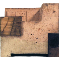
the woman, germanic; the man, ancestry bretonic
the woman came from the southern german tribes around lake bodenzee and ended her life, 2 years short of a century lies in west penwith. the man whose ancestry descends from brittany was born in a london tenement near lambeth

the woman, germanic; the man, ancestry bretonic
the woman came from the southern german tribes around lake bodenzee and ended her life, 2 years short of a century lies in west penwith. the man whose ancestry descends from brittany was born in a london tenement near lambeth
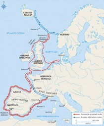
pytheas journey to britain ca 325BC
pytheas lived in the greek colony of massilia (near present-day marseilles, france), and documented his seaward exploration of northwest europe in on the ocean, a work which was cited by later authors such as strabo and pliny the elder. prior

pytheas journey to britain ca 325BC
pytheas lived in the greek colony of massilia (near present-day marseilles, france), and documented his seaward exploration of northwest europe in on the ocean, a work which was cited by later authors such as strabo and pliny the elder. prior
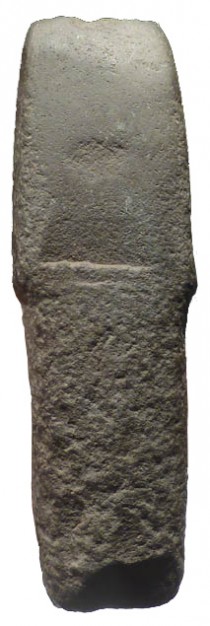
neolithic axe head
hardstone axe head. period: european neolithic/chalcolithic (cucuteni-trypillian culture) 5500-4600BC provenance: east europe.measurements: 17.8 cm long x 5.5 cm wide. the cucuteni-trypillian culture extends from the carpathian mountains to the dniester and dnieper regions, centered on modern-day moldova and covering substantial parts of western ukraine
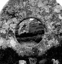
men-an-tol
this holed stone was formed gradually over long periods of time by wind agitation on rain water pools sitting on the surface of the granite tors. this one turned through 90 degrees is part of the men-an-tol stone circle and may

men-an-tol
this holed stone was formed gradually over long periods of time by wind agitation on rain water pools sitting on the surface of the granite tors. this one turned through 90 degrees is part of the men-an-tol stone circle and may
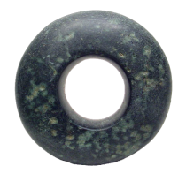
7200 year old mace head
green hardstone mace. period: neolithic of capsian tradition 5500-2000 b.c. provenance: north african sahara desert. measurements: 15 cm outer diameter, inner opening 6 cm, 5cm thickness

7200 year old mace head
green hardstone mace. period: neolithic of capsian tradition 5500-2000 b.c. provenance: north african sahara desert. measurements: 15 cm outer diameter, inner opening 6 cm, 5cm thickness
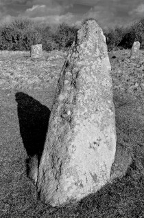
stone axe menhir
it is suggested that the axe shaped centre longstone at boscawen-un stone circle probably predates the other stones that make up this elliptical stone circle. like an axe head struck into the ground, it is thought that it has always

stone axe menhir
it is suggested that the axe shaped centre longstone at boscawen-un stone circle probably predates the other stones that make up this elliptical stone circle. like an axe head struck into the ground, it is thought that it has always
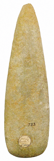
cornish stone axes
cornish axes stone axes are grouped according to petrological, mineralogical and textural criteria. over 40 different axe groups are recognised from a total of 7625 axes found in britain (of which only 3546 have been grouped) (clough and cummings, 1988).

cornish stone axes
cornish axes stone axes are grouped according to petrological, mineralogical and textural criteria. over 40 different axe groups are recognised from a total of 7625 axes found in britain (of which only 3546 have been grouped) (clough and cummings, 1988).